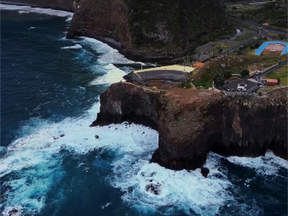
LOCAL · SANTANA · Cortado → Ponta do Clérigo Promontory
UNKNOWN TRAIL · PONTA DO CLÉRIGO · LEVADA · FREE
Ponta do Clérigo
6.2 KM · 2H15–2H45 · MODERATE · CORTADO TO PONTA DO CLÉRIGO PROMONTORY
Cortado
Trailhead Access · Free Roadside Parking
Adega do Pomar
Hearty traditional fare after north-coast routes
Ponta do Clérigo Promontory
Trail End
Exit Terminus (Ponta do Clérigo Promontory)
6.2 KM Total Route
[X]Unmaintained Ridge Path
Unpatrolled Crest · Steep Cliff Drop-offs
OPTIMAL WINDOW: 08:30 - 11:00 FROM CORTADO — SHADED LAURISSILVA CANOPY; EXPECT DAMP LEDGES
HIGH VERTIGO EXPOSURE: NARROW CLIFF LEDGES WITH DROP-OFFS — RIGID SOLED BOOTS & SURE FOOTING ESSENTIAL
POINT-TO-POINT FINISH AT PONTA DO CLÉRIGO PROMONTORY: RETURN TAXI EST. €25.00 - 35.00 OR PRE-ARRANGE SHUTTLE
Distance
6.2 km
2 h 15 min · 380 m ascent and descent
IFCN Fee
Free
Return to Car
—
Area / Difficulty
Santana · Moderate
Status note. 12 October 2026: 6.2 km, moderate cliff ridge walk, 2 h 15 min. Not an IFCN figure. IFCN does not maintain this walk. Updated 12 Oct 2026.
Ponta do Clérigo is 6.2 km, moderate cliff ridge walk. Not on the IFCN list.
Interactive Field Calculators & Logistics Tools (Shuttle, Cost, Microclimate & Offline Card)
Closure & Congestion Mitigation
Twin-Trail & Plan-B Engine
Because parts of Ponta do Clérigo are currently restricted or closed under IFCN decree, hike these verified open twin routes with matching terrain DNA, elevation drama, and scenery.
PR 8 Ponta de São Lourenço
Iconic open coastal trail with ocean views
PR 11 Vereda dos Balcões
Accessible viewpoint walk through native forest
Field Logistics Intelligence
Return-to-Car & Linear Loop Solver
Point-to-point routes end away from your vehicle. Review verified 2026 public bus lines, taxi fares, midpoint key swaps, or connecting footpaths to return to Cortado (Santana).
Line: SIGA Regional Service
CAM (SIGA) eastern/northern routes
Coordination & Taxi-Split Action
Send this verified return plan to your group via WhatsApp or SMS.
Field Hazard & Body Impact Intelligence
Reality Matrix: Tunnels, Vertigo & Knee Strain
Beyond generic difficulty ratings: quantitative engineering metrics on pitch-black irrigation tunnels, abyss exposure tiers, and knee-joint impact on steep Caminho Real cobblestones.
0 m
Open air route
Tunnel-free routing with natural daylight throughout.
Tier 2+ · High Exposure
Exposed cliff edges and natural drop-offs along the trail margin.
Not recommended for hikers with severe acrophobia or vertigo sensitivity.
Level 2+ · Strenuous Stone Steps
Steep elevation change and stone steps place continuous strain on knees.
Trekking poles strongly recommended to absorb eccentric downhill shock on rounded stones.
Atlantic Microclimate Intelligence
Live Island Clock & Microclimate Advisor
Simulate your planned departure hour to beat the cloud inversion ceiling, trade-wind fogs, and trailhead parking saturation.
Prime trail window: 08:30 - 11:00
Trailhead Parking
Ample · Laybys empty
Cloud Ceiling Risk
Clear skies · Above cloud sea
Trail Congestion
Very Light · Trail to yourself
Sun & Wind Load
Cool & Crisp · Light windbreaker
Field advisory: Protected forest canopy keeps temperatures cool; expect damp surfaces under laurel trees.
2026 IFCN & SIMplifica Tariff Engine
Permit, Parking & Transfer Cost Estimator
Calculate your exact party outlay under the 2026 SIMplifica regulatory regime, including legal resident and child exemptions, parking caps, and return transit.
Adult Hikers (> 12 years)
Standard permit €0.00
Children (≤ 12 years)
100% Legally Exempt (€0.00)
Madeira / PT Residents
100% Resident Exemption (€0.00)
Forest Police (Corpo de Polícia Florestal) inspect digital tickets at trailheads. Fines of €50–€500 apply for unregistered hikers.
Offline Survival Pocket Card: Ponta do Clérigo
Essential route facts and offline navigation notes for remote terrain with zero cellular signal
Start Trailhead GPS
32.8089° N, 16.8656° W
Cortado (Santana) · 380 m elevation
GPS: 32.8089, -16.8656
Finish / Terminus GPS
32.8050° N, 16.8822° W
Ponta do Clérigo Promontory · 380 m elevation
GPS: 32.805, -16.8822
Distance
6.2 km
Estimated Time
2 h 15 min
Elevation Profile
380 m ascent and descent
Difficulty Grade
Moderate
Emergency SOS & Civil Protection
112 — European Emergency SOS (Universal)
Civil Protection (Proteção Civil): +351 291 700 112
IFCN Forest Police (Polícia Florestal): +351 291 102 700
VHF Marine Ch. 16 / Mountain SAR
Rule:Cardinal Survival Rule: Stay strictly on the levada path. Never descend into stream gorges or waterfalls. If cloud ceiling descends, halt and wait in place.
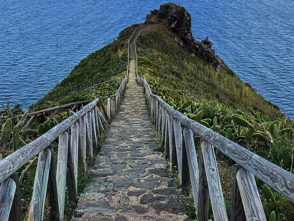
Projecting out into the open waters of northeastern Madeira, Ponta do Clérigo represents a spectacular unpatrolled coastal ridge hike starting from the rural parish of Cortado in Santana and terminating at the dramatic tip of the oceanic promontory. Combining quiet agricultural levada paths with an exhilarating razorback basalt crest, this trail provides panoramic vistas across the Atlantic Ocean, the imposing monolithic rock of Penha d'Águia, and the distant headland of Ponta de São Lourenço. Because it is an unclassified local track that does not belong to the official Percursos Recomendados network, it has no official forestry markers, no regulatory fee requirements, and no maintained guardrails along exposed sections.
Route Profile & Terrain Details
- Surface conditions underfoot: Hikers on Ponta do Clérigo follow narrow dirt levada banks, grassy headland paths, and weathered basalt rock outcroppings along the ridge spine.
- Vertical exposure and protection: The outer promontory involves narrow crest walking where steep grassy and rocky slopes plunge directly into the ocean on both flanks with no security fences.
- Gradients and elevation profile: The trail descends approximately 380 meters from Cortado toward the promontory tip, requiring a steady uphill climb on the return leg.
- Hydrological conditions and weather exposure: Strong easterly and northerly maritime trade winds buffet the unprotected ridge, and sudden coastal mists can reduce visibility across the headland.
Trailhead Access, Parking & Return Transfer
- Road approach and connectivity: Approaches follow the northern VE 1 expressway and ER 101 regional corridor into Santana, turning off at Cortado near the local residential area and church chapel.
- Trailhead parking availability: Roadside parking bays along the quiet rural lanes of Cortado provide convenient access, provided vehicles do not block agricultural gates.
- Public transit connections: Public transport via CAM (SIGA) northern services linking Funchal, Machico, and Santana reaches bus stops along the main Cortado road.
- Return logistics and transfer options: Because the route terminates at the tip of the ocean headland, hikers retrace their footsteps back to the starting point in Cortado in an out-and-back format.
Historic Landscape & Heritage Context
The coastal cliffs of Santana have long been intertwined with island agriculture and maritime surveillance. The upper section of Ponta do Clérigo winds through traditional smallholdings where local farming families cultivate terraced orchards of custard apples, vineyards, and cabbages irrigated by modest earthen channels. Further along the spine, the headland served historically as an observation post for local fishermen scanning the offshore currents for passing tuna schools and seabird flocks. The dramatic geology showcases layered volcanic ash (bagacina) and dark basaltic lava flows that have withstood millenia of ceaseless Atlantic wave erosion.
Field Safety & Official PR Alternatives
Venturing onto Ponta do Clérigo requires good balance and steady nerves along high drop-offs. The narrow ridge section is not suitable for anyone suffering from acute vertigo or during periods of high wind, when powerful gusts can compromise stability on the open crest. Wear sturdy walking shoes with aggressive tread for traction on dry grass and loose dirt. Sun protection, windproof clothing, and plenty of drinking water are essential, as there is zero shade along the exposed promontory. If cloud banks roll in and obscure the narrow path, stop and retrace your route back to the shelter of the inland levada.
Official classified PR alternatives near Santana
Walkers looking for certified hiking routes with reliable signposts and official forestry clearance in Santana should consider these recommended classified alternatives to Ponta do Clérigo:
- PR 9 Levada do Caldeirão Verde — 6.5 km each way (13.0 km there and back) starting from Parque Florestal das Queimadas in Santana (listed open on the 2 October 2026 IFCN table). Offers a world-renowned certified levada walk through ancient laurel forests with secure handrails and dramatic waterfalls.
- PR 1.1 Vereda da Ilha — 8.2 km connecting Pico Ruivo down to the village of Ilha in Santana (listed open on the 2 October 2026 IFCN table). Delivers a verified mountain descent through prime cloud forest with full IFCN oversight.
- PR 18 Levada do Rei — 5.3 km each way (10.6 km there and back) along the Ribeiro Bonito gorge in Santana (listed open on the 2 October 2026 IFCN table). Features certified footpaths along clear mountain streams with active trail monitoring.
Other unpatrolled routes documented in the Santana district include Levada do Cortado and Vereda da Rocha do Navio, cataloged in the unknown trails guide outside official forestry jurisdiction. Documentation source for Ponta do Clérigo: Santana municipal terrain archives and regional coastal trail surveys, contrasted with IFCN Percursos pedestres classificados (updated 2 October 2026, read 12 October 2026).
Specifications & facts
- Type
- Levada
- Area
- Santana
- Difficulty
- Moderate
- Distance
- 6.2 km
- Time
- 2 h 15 min
- Elevation
- 380 m ascent and descent
- Start
- Cortado (Santana)
- Finish
- Ponta do Clérigo Promontory
Post-Hike Refuel & Dining Radar
Authentic Post-Hike Hospitality
Trailhead & Village Refuel Radar
Nothing defines Madeiran hiking culture more authentically than gathering at a rustic mountain bar or fisherman's tasca right after the trek. Verified local venues within minutes of the finish:
Adega do Pomar
Field photographs along the channel